+977-9851241796
[email protected]

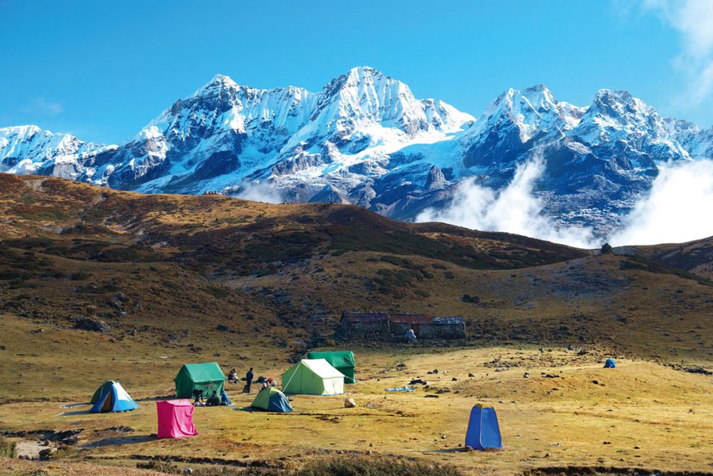
Annapurna Circuit Trek is the most visited trekking trail in Nepal. The trek is one of contrasts between the green, terraced farmland on the start point to the semi-arid environment of the destination point. Annapurna region Trekking starts from Nayapul which is about 1 and half hour drive from Pokhara Valley. The beauty of the nature and the hospitality of the people living there make each day of your travel in this area a memorable one. Annapurna region trek passes through the forest of sakura trees and rhododendron in most. The blooming seasons makes the trek to feel as you are entering the Shangri-la.
This trek gives you the varied view of landscapes and the queue of Himalaya peaks spotting the famous ones as Dhaulagiri, Annapurna I, II, III and IV, Mt. Fishtail, Himalchuli, Gangapurna,etc. One can see the amazing natural facts like the deepest gorge in the world, Kali Gandaki Gorge along with the Shaligram (the fossil-stones) while going through this region. Most of the landscapes re dotted with the Tibetan prayer flags. It is also the gate way to the Lake Tilicho which is located at the highest elevation on Earth.
Tribhuvan International Airport (Google Map)
3 Hours Before Flight Time
Altitude: 1,400m/4,264ft
The very time you land, you will be met and warmly greeted by Merit Adventure representative at the Tribhuwan International Airport (TIA). Look sharply for a placard with your name on it. Once you are done with the custom formalities (visa, etc) we’ll get your luggage and escort you to your hotel. We’ll help you check into your hotel then depending upon your mood, you can either visit Merit Adventure office or take a rest in your hotel room. Free to explore on your own. Overnight in Kathmandu.
Altitude: 1,300m/4265ft| Drive 8 – 9 hrs
Today we will meet you at your hotel early in the morning and pick you up so to start our journey. It takes 8-9 hrs of driving on a private vehicle to Jagat, a stone village in Lamjung district. By the time we reach here we are already ahead of Besi sahar which is also known as the gateway to Annapurna circuit trekking, Bhulbhule and a picturesque village of Bahundada. Right after we enter Besisahar we will witness stunning snow capped mountain panorama and culture and traditions of Gurung community, people from one of the community of few selected communities who takes pride to join in British Army. Overnight stay in Jagat.
Altitude: 1,960m/6,430ft| Trek 7 – 8 hrs
Today we will start our day after breakfast climbing through the forest to Chyamje. We trek through amphitheater-shaped rice terraces, along a steep vertical cliff, lush forests, and some culturally intriguing villages. We follow the Marsyangdi river, as we walk in a fantastic landscapes through little waterfalls, forests and villages. As we climb through the steep hills of Chamje to reach Dharapani, we pass through the first village of Manang district named Tal through the fields of corn, barley, potatoes and forests filled with bamboo and rhododendrons strongly popular for being Nepal’s national flower. During our trek we will experience the serene mountain climate and culture. As we walk, we are heading higher in slow pace sometimes giving passes to caravan of large group of donkey as it helps us getting acclimatized to altitudes. Overnight in Dharapani.
Altitude: 2,710m/8,891ft| Trek 6 – 7 hrs
Today with pleasant walk, we trek gradually up hill through steep forest ridges and several landslides to the west. With superb sensational scenery of Lamjung himal (mountain) and frequent views of Annapurna range, including Annapurna II and Annapurna IV. Treat yourself with small hot springs, waterfalls and a big wall full of prayer flags as we reach Chame, the headquarter of Manang district. Overnight at Chame.
Altitude: 3,300m/10824ft: Trek 5 – 6 hrs
Today, we will leave the village of Chame. We will pass through the pine tree with amazing view of rocks, walk out past the prayer wheels and cross wide rivers and pine forests on the way to Pisang. steep and narrow path through a very dense forest will bring us to the dramatic curved rock face, rising 1500m from the river. The forests and heavy vegetation would now be gone. We cross and re-cross the river again and again on suspension bridges. As the trail opens up we get surrounded by majestic Himalayan Peaks. The view of the soaring Paungda Danda’s rock face really begins to appear. From there the trail joins to climb to Pisang, which sprawls between 3,200m and 3,300meters. We find ourselves in U-shaped valley of Manang hanging between two giant snow peaks. Upon walking through these wonderful sites we reach at Pisang. Overnight in Lower Pisang.
Altitude: 3,540m/11,328ft|Trek 6 – 7 hrs
Today our trek will cross the Marsyandi River on the way out to Manang. Pisang to Manang (3,400m) starts through almost flat road. Tall rocks and Hongde airport are the main attractions of the day. The southern route by Hongde, with its airstrip at 3,325m, involves less climbing than the northern route via Ghyaru, though there are better views on the trail that follows the northern bank of the river. From Mungji, the trail continues past the picturesque but partially hidden village of Bryanga at 3,475m to the nearby Manang at 3,540m. We have disjunctures of two routes that we follow. If taken upper route (Wind Horse recommends), i.e., the route through Upper Pisang via Geru, we will have outstanding sceneries. We feel like we are horizontally in front of the majestic peaks. The panoramic views of the mountain peaks, such as Annapurna, Pisang peak, and several others will definitely allure us. We experience a contrast with the landscape and vegetation from today. On the way, the cold and dry climate creates a much harsher environment. Our short visit to Barge monastery, the largest in the entire district of Manang will be memorable. Overnight in Manang.Altitude: 3,540m/11,328ft|Trek 6 – 7 hrs
Today our trek will cross the Marsyandi River on the way out to Manang. Pisang to Manang (3,400m) starts through almost flat road. Tall rocks and Hongde airport are the main attractions of the day. The southern route by Hongde, with its airstrip at 3,325m, involves less climbing than the northern route via Ghyaru, though there are better views on the trail that follows the northern bank of the river. From Mungji, the trail continues past the picturesque but partially hidden village of Bryanga at 3,475m to the nearby Manang at 3,540m. We have disjunctures of two routes that we follow. If taken upper route (Wind Horse recommends), i.e., the route through Upper Pisang via Geru, we will have outstanding sceneries. We feel like we are horizontally in front of the majestic peaks. The panoramic views of the mountain peaks, such as Annapurna, Pisang peak, and several others will definitely allure us. We experience a contrast with the landscape and vegetation from today. On the way, the cold and dry climate creates a much harsher environment. Our short visit to Barge monastery, the largest in the entire district of Manang will be memorable. Overnight in Manang.
Today is the scheduled acclimatization day. The dramatic setting of Manang makes for a pleasant rest and acclimatization day with the added benefit of hot showers. It is not recommended to stay idle but a short walk to higher altitude is suggested to get acclimatized with the altitude. The upcoming next two days will be very challenging and tiring trek for us with rapid gain in altitude. We should never be confident with the altitude and always be cautious. Bhojo Gompa or Gangapurna Lake is worth visiting sites from acclimatization point of view. Further, we pay an easy excursion to a little distance away to a village called Vraga, upon wherre we will be at a village’s monastery. Overnight in Manang.
Altitude: 4,110m/13,484ft|Trek 3 – 4 hrs
After a day rest at Manang, we continue our adventure the next day. From Manang, first you’d head out to the village of Tenki. The trail leads uphill leaving the Marshyangdi Valley to reach Jarsang Khola. As you carry on ascending you’d traverse pastures and juniper forests. The trail continues passing by Ghunsa a small hamlet which later passes meadows where you can find yaks and horses grazing. Later you’d cross the river and continue walking on its southern side through coniferous forest. After reaching Kangsar Village we walk further up towards Yak Kharka and pass a monastery on the way. The uphill walk could be tiring but we will have Gungang Himal and Mt. Chulu in the backdrop to keep us company. Overnight in Yak Kharka.
Altitude: 4420m/14501ft|Trek 3-4 hrs
Today, you’d leave Yak Kharka after breakfast and move ahead with our trek first to Ledar. You’d walk through fantastic sceneries. The walk is relatively flat and short, yet seems to take forever. It’s a short walk from Yak Kharka to Ledar. Then, you’d slowly to make your way to the foot of the pass, Throng Phedi. It is a small busy settlement with amazing view of mountains and landscapes. People use this place as a base. Phedi means foot of the hill is a common Nepali name for any settlement at the bottom of a long climb. You’d stay overnight at guesthouse. From Ledar, you’d ascend furthermore and pass through towering cliffs before reaching Thorang Phedi, the last village before Thorong La. On this trip you are rewarded with one of the best views of Mt. Gundang, Mt. Syagang, Thorung Peak and Mt. Khatungkan. Overnight in Thorang Phedi.
Altitude: 3,800m/12,467ft| Trek 8 -9 hrs
Today, you’d walk the longest and hardest day of the entire trip. Crossing Thorong La pass it is a lifetime experience, one of the highest and famous passes in the world will be your ultimate objective today. You will be crossing the pass from east to west (Manang to Muktinath) which is the easiest and safest direction. You’d need to get up around three in the morning and walk up the mountain. When you finally make it to the top, you’ll realize that our journey was worth it. You can take a few photos before heading to Muktinath Valley at the foot of the Thorong La pass. Overnight in Muktinath.
Altitude: 1,200m/3937ft|Trek 6 – 8 hrs
Today, you will drive through new route to Tatopani. The trail is descending till you cross the bridge at Ghasa. As you drive to lower elevation, you’d emerge back into subtropical forests, lush with vegetation. The journey is smoothly downhill to Rupse Chahara (Famous waterfall) via garpar to a bridge at Dana. Here you will see the local powerhouse that supplies electricity in the area. The trail again descends slightly to Tatopani through different human settlements. Upon reaching Tatopani, you relax and have a bath in the hot spring. You’d stay overnight at guesthouse in Tatopani.
Altitude: 2,850m/9,350ft|Trek 7 – 8 hrs
Today, you’d leave the Kali Gandaki and headed up the Ghar Khola valley. The trail leads us through a terraced farmland with mountains all around. While you walk you can observe the lifestyle of the people in the midland villages of Nepal. You’d pass through the terraced and inclined farmlands villages of Shikha and gradually ascend to Ghorepani passing through Phalate and Chitre before reaching a beautiful rhododendron forest, brich, magnolia and some meadows. When in bloom the rhododendron trees with its average height of up to 100″ will be covered with pink or red flowers. As you gain the height the peaks ahead look wonderful. Walking furthermore you’d reach Ghorepani, a beautiful village located at a ridge top. Overnight in Ghorepani.
Altitude: 2,700m/8,860ft|Trek 6 – 7 hrs
Today, to catch the sunrise over the Himalayas, you’d need to make an early morning climb along the steep trail to the viewpoint of Poon Hill (3,210m/10,529ft), the most popular trekking destination of the Annapurna region. It is also a great viewpoint to enjoy the amazing views of Mustang, Pokhara and more than 20 of the highest mountains including the close-up views of the Annapurna and Dhaulagiri ranges. The snowy peaks of the high mountains loom above and around us glowing in the morning light. After taking photographs, you return back to Ghorepani. After breakfast, you head east and climb a nearby ridge. You’d descend through rhododendron forests, pass by spectacular waterfalls and reach Tadapani to spend the night. Overnight in Tadapani.
Trek 6-7 hrs trek| Drive 1 hr
Today, you’d trek from Tadapani until Ghandruk through a thick forest of rhododendron trees. After trekking for a while, you’d enter the village of Ghandruk, a slope settlement with stone houses mostly inhabited by the Gurung people. From here, you’d enjoy the towering views of the Fishtail, Annapurna South, and Hiunchuli mountains. The trek further continues to Naya Pul then followed by a drive to Pokhara. Overnight in Pokhara.
Drive 6-7 hrs
After breakfast, you’d be saying goodbye to the beautiful lake city of Pokhara and drive towards Kathmandu on a tourist bus. After reaching Kathmandu you will have rest of the day off to rest or do some souvenir shopping. To celebrate the successful completion of your journey, you will have a farewell dinner in the evening, and you can select your choice of meal from a well crafted menu at one of the recommended local restaurant. Overnight in Kathmandu.
Included meals: Breakfast and Dinner
Our adventure in Nepal comes to an end today! Our representative will escort you to the airport approximately 3 hours before your scheduled flight. On your way home, you will have plenty of time to plan your next adventure in the wonderful country of Nepal. See you again my friend!